


Reducing The Transmission Footprint
We care about the environment and potential impacts where our facilities exist. As part of our regulatory applications for the Cardinal-Hickory Creek Transmission Line Project (C-HC Project), the co-owner utilities completed a comprehensive environmental review to identify Mississippi River crossing locations that would minimize impacts to and provide a net conservation benefit for the Upper Mississippi River National Wildlife and Fish Refuge (Refuge) and the Mississippi River.
The federal agencies involved in the permitting process for the river crossing reviewed these routes (which is further detailed in the next section) and in the process, have fully complied with the National Environmental Policy Act (NEPA). In addition, the U.S. Fish and Wildlife Service (USFWS) has multiple sources of authority to allow the project to cross the Refuge with appropriate environmental conditions.
After years of analysis by both the co-owner utilities and the federal agencies, our preferred route (also the selected route), will reduce environmental impacts in the Refuge because we will relocate and remove existing transmission infrastructure. Specifically, we will co-locate (or “double-circuit”) the existing 161-kV line that currently crosses the Refuge with the new 345-kV Cardinal-Hickory Creek line. Upon completion of construction, the existing 69-kV line that currently cross the Refuge will be de-energized and removed.
The net benefit of these shifts in infrastructure will reduce the electric transmission footprint in the Refuge, reduce habitat fragmentation within the Rrefuge, and will replace existing structures with low-profile structures using an avian-friendly design. In addition, the number of structures in the Refuge will be reduced by approximately half.
Considerations for Crossing the Refuge and Mississippi River
The Refuge extends north to south through Minnesota, Wisconsin, Iowa, and Illinois for approximately 260 river miles, covers just over 240,000 acres, and is designated as a Wetland of International Importance and a Globally Important Bird Area. About 1.1 miles of the approximately 102-mile Cardinal-Hickory Creek line will cross the Refuge.
We recognized early on that the Cardinal-Hickory Creek line would need to cross this region, which is a major avian flyway. We also recognized the importance of collaboration with USFWS to develop a route that would minimize impacts associated with the crossing. Beginning in 2012, we retained experienced environmental consultants to aid us in selecting the route that ultimately would become our preferred route.
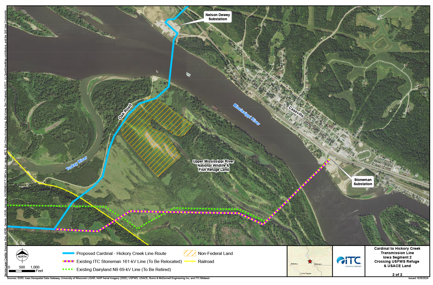
At present, two existing transmission lines cross the Mississippi River from Clayton County in Iowa to the south end of the Village of Cassville in Wisconsin.
Within the Refuge, engineers have developed plans to retire the existing 69-kV line and co-locate the existing 161-kV line with the C-HC Project. This means that the two existing transmission corridors will be reduced to one after the project is constructed and the existing rights-of-way will be re-vegetated according to a restoration plan approved by the USFWS and U.S. Army Corps of Engineers, providing a net conservation benefit to the Refuge.
Agency Consultation for Alternatives Crossing
The route of the C-HC Project through the Refuge results from years of agency consultation and evaluation. The co-owners began meeting with the USFWS in April 2012 to seek input on routes for the project, particularly within and in proximity to the Refuge. As part of that consultation, the USFWS Refuge manager advised that the agency would not consider a crossing through the Refuge unless the co-owners could demonstrate that non-Refuge alternatives were infeasible.
To meet USFWS’s requirement, ITC Midwest, ATC and Dairyland Power Cooperative (Dairyland) undertook an Alternative Crossings Analysis (ACA). The multi-year analysis concluded in April 2016 and is available here. The 359-page ACA documents the in-depth route identification and evaluation process the co-owners completed. The study area extended from Guttenberg, Iowa, on the north end to approximately 45 miles to the south in Dubuque, Iowa and identified seven potential crossing locations – including areas of existing transmission, and road and bridge infrastructure over the Mississippi River (four of these options were outside the Refuge and three within).
ITC Midwest, ATC and Dairyland rigorously evaluated each crossing location to determine if it was technically and reasonably feasible to construct the C-HC Project outside the Refuge. See map for evaluated crossing locations.
Refuge Crossings
- Lock and Dam No. 10 in Guttenberg, Iowa (L&D 10)
- Turkey River Substation to the Nelson Dewey Power Plant crossing in Cassville, Wisconsin (Nelson Dewey)
- Millville to Stoneman 69-kV transmission line and Turkey River to Stoneman 161-kV line crossing (co-located) in Cassville, Wisconsin (Stoneman)
Non-Refuge Crossings
- Lock and Dam No. 11 in Dubuque, Iowa (L&D 11)
- Highway 61/151 crossing in Dubuque, Iowa (Highway 151 Bridge)
- Dubuque to Galena 161-kV line crossing in Dubuque, Iowa (Galena 161-kV Line)
- Julien Dubuque Bridge/Highway 20 crossing in Dubuque, Iowa (Julien Dubuque Bridge)
As part of the ACA effort, we provided information to and sought analyses from federal, state and local entities with permitting authority over the relevant crossing locations. The results showed that non-Refuge ACA routes (as well as the L&D 10 crossing location within the Refuge) presented technical engineering conflicts with existing infrastructure, and human and environmental impacts that would preclude the issuance of necessary permits.
For example, the L&D 11 crossing would impact 58 homes in Dubuque that would be within 100 feet of centerline of transmission line corridor, nine of which would be within 25 feet. The United States Army Corps of Engineers also concluded it could not issue a permit for the crossing due to safety and technical engineering concerns.
Our Preferred Route is the Selected Route
Following the multi-year evaluation and analysis, the second and third ACA river crossing locations through the Refuge, Nelson Dewey and Stoneman, were presented to the USFWS for further evaluation and approval. We advocated for the Nelson Dewey crossing as the preferred crossing because:
- The Nelson Dewey alternative crossing location connects at a retired coal plant property in the Village of Cassville, Wisconsin. It also follows existing transmission line right-of-way east toward the remaining C-HC Project termination points in Wisconsin. In other words, the Nelson Dewey crossing location ties directly into existing 138-kV corridors that extend into the project’s intermediate substation location. Following existing transmission line corridors is the top priority for transmission line siting under Wisconsin’s Siting Priorities law.
- The Stoneman crossing would route the C-HC Project through the Village of Cassville on the Wisconsin side of the Mississippi River.
- Alternative Wisconsin route alignments at the Stoneman crossing location are constrained by the presence of the Cassville Municipal Airport (the runway is located approximately 2,000 feet from the crossing location).
- The preferred Nelson Dewey crossing location would locate the C-HC Project farther away from known areas that support resting and feeding habitat for migratory avian species, including Wood Duck Slough and Dead Lake.
The USFWS ultimately approved and granted a right-of-way permit for the project to cross at Nelson Dewey in September 2020. However, the USFWS subsequently withdrew the permit in August 2021 based on an error it made in identifying the correct easement documents for the existing transmission line rights-of-way. In February 2024, the USFWS approved a land exchange that will enable the C-HC Project to cross the Refuge via a slightly modified Nelson Dewey crossing, known as B-IA3.
Structure Design will Benefit Avian Flyway and Vegetation
The C-HC Project is specifically designed to minimize impacts to birds by leveraging industry leading techniques that are not present on the existing transmission line crossings in the Refuge.
The structure design that will be constructed across the Refuge is low-profile, H-frame. With the exception of one structure at the River crossing, the structures within the Refuge will be no more than 75 feet tall. (The taller structure within the Refuge will be just under 200 feet and is designed to meet federal transmission clearance requirements across the river.)
This special low-profile design will minimize potential avian impacts by keeping all of the electric transmission wires on one horizontal plane to match the existing tree canopy in the Refuge so that birds will fly over – not through – the transmission line. Furthermore, the design incorporates bird diverters on the wires, which are not currently part of the existing infrastructure through the Refuge.
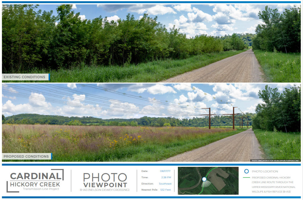
The larger 345-kV transmission structures will be more easily seen by avian species. In addition, the reduced span length (500-600 feet) and use of flight diverters will limit avian interactions by increasing overall visibility of the transmission line.
Vegetation removal will also be minimized – only an estimated 35 trees (greater than 14 inches in diameter at breast height) will be removed to accommodate line construction across the approximatey 1.1-miles in the Refuge.
The C-HC Project will create a net benefit to the Refuge by following an existing road and consolidating infrastructure rights-of-way through the Refuge, thereby reducing transmission line impacts in the Refuge.
As articulated in prior sections of this website, the two existing transmission lines at Stoneman will be removed and the 69-kV line will be de-energized and removed. The 161-kV line will be relocated to B-IA3 along Oak Road and co-located with the proposed 345-kV transmission line. The existing transmission line easements will also be released. This will allow the utilities to complete restoration of the existing ROWs back to a more natural state according to the USFWS and U.S. Army Corps of Engineers approved restoration plan. The total restoration will encompass approximately 28 acres.
The Proposed Land Exchange Adds High Value Acreage to the Refuge
ITC Midwest and Dairyland Power Cooperative proposed to USFWS that it consider a land exchange to enable the C-HC Project to be constructed at the Nelson Dewey crossing. The C-HC Project approved land exchange adds high value acreage to the Refuge furthering the overall mission of the Refuge.
The National Wildlife Refuge System Administration Act, as amended by the 1997 National Wildlife Refuge System Improvement Act, authorizes the Secretary of the U.S. Department of the Interior (Department) to “[a]cquire lands or interests therein by exchange for acquired lands or public lands, or for interests in acquired or public lands, under his jurisdiction which he finds to be suitable for disposition.”1 When evaluating a proposed land exchange under this statute, the U.S. Fish & Wildlife Service (FWS) “should consider the exchange as a whole, including known planned uses for the divested land, and determine whether the exchange would likely result in an overall conservation benefit for the [National Wildlife Refuge System] and individual refuge.” The agency “should only proceed with exchanges that would provide a net conservation benefit and further the individual refuge’s purposes. Of course, it follows that if there is a net benefit to the refuge subject to the exchange, the Refuge System as whole likewise receives a benefit.”
Under the approved land exchange that was completed on May 9, 2024, the USFWS transferred by deed, 19.84 acres of land within the Refuge to ITC Midwest and Dairyland Power Cooperative. In exchange, the utilities transferred by deed, 35.69 acres – nearly double the acreage transferred by USFWS – of private land called the “Wagner” parcel for incorporation into the Refuge. The Wagner parcel is unencumbered by any road or utility infrastructure. USFWS identified the Wagner parcel as a high priority target for acquisition in its planning documents due to its environmental characteristics.
The USFWS-approved land exchange involving two of the co-owner utilities – ITC Midwest and Dairyland Power Cooperative – was the last major regulatory approval to facilitate completion of the project. The land exchange provides important net benefits to the Refuge. These benefits are described in detail by the USFWS in the Land Exchange Net Benefit Analysis, which found that “the proposed land exchange fulfills the Refuge’s purposes by exchanging lower quality habitat for higher quality habitat, increasing the total protected acreage in the Refuge, reducing habitat fragmentation in the long term, and allowing the Refuge to acquire a high-priority tract that would not otherwise be available. Each of these factors will further the purposes of conserving and maintaining refuge and breeding places for birds, animals, fish and plants. Acquisition of the Wagner tract provides value for wildlife-dependent recreation on the Refuge, such as hunting, fishing and wildlife observation, which is directly related to the purposes of this Refuge and of the National Wildlife Refuge System as a whole.”
The Net Benefit Analysis further notes that “Acquiring and preserving the shoreline protects these sensitive areas from development and reduces the potential for erosion that could impact the endangered Higgins Eye pearlymussel and other sensitive aquatic species.”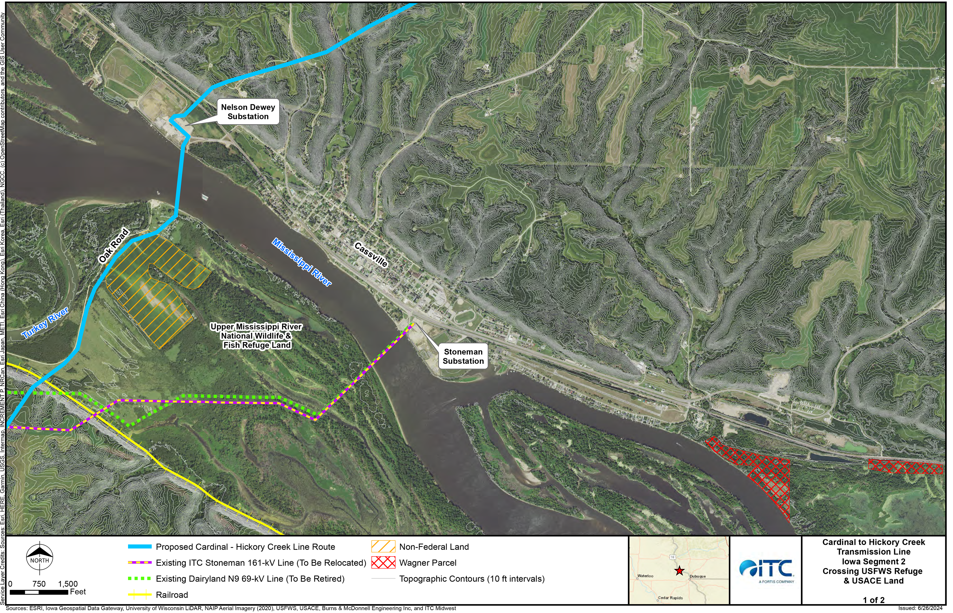
Our Commitments for Constructing in the Refuge
ITC Midwest and Dairyland Power Cooperative are committed to constructing the C-HC Project in the Refuge in a manner that minimizes environmental impacts through mitigation measures and best management practices. All work within the Refuge for construction of the project is being completed using wooden construction mats for environmental protection. No grading will take place within the Refuge. These efforts will help avoid and minimize impacts to plants, animals and their habitats, and limit habitat fragmentation. These commitments include a robust set of mitigation and restoration methods resulting from years of agency consultation through the permitting process, ensuring:
- Construction is completed pursuant to the Federal Mitigation Plan.
- The restoration of the Stoneman ROW complies with the Updated Restoration Plan for the Upper Mississippi River Refuge Near Turkey River Iowa (December 2021).
- Vegetation Management will be done in conformance with the Vegetation Management Plan (July 15, 2020).